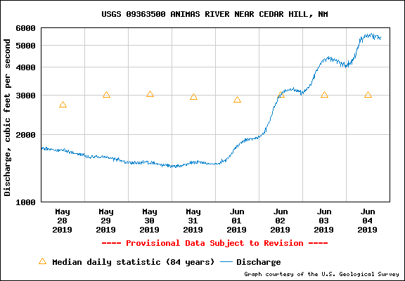
High flows in the Animas and San Juan Rivers have created dangerous conditions. The rivers are both running higher, and faster than recent memory. Faster running water has the potential to make the bank unstable. Be careful around the riverbank. Even experienced swimmers can be overpowered by the extreme river current. Stay out of the main channel during periods of high flow. Both rivers are deeper than normal and likely to be over your head. In shallow areas, the water could still knock you off your feet.
As temperatures continue to rise through the spring season, San Juan County Office of Emergency Management is keeping a close eye on measurements of water flowing in the Animas River. Likewise, special attention is being paid to the San Juan River as the Bureau of Reclamation has begun the spring release from Navajo Dam.
San Juan River
Over the next week, the flow in the San Juan River will gradually increase to 5,000 cubic feet per second (cfs). The flow will remain at that rate for about five days before the river level will ramp back down. The high flows mimic the natural increase of water during the spring. The increase serves to clean the river channel of debris and silt build up on the river bottom. Since flows have not been this high in several years, there is the possibility of erosion and minor flooding along the river banks and in low lying areas. Residents in flood-prone areas are encouraged to prepare their property by removing anything too close to the river bank. If sandbags are necessary, San Juan County Office of Emergency Management has provided sand and sandbags to be filled by residents at 326 S. Oliver Dr. in Aztec. If an emergency is declared, San Juan County may be able to help in filling and placing sandbags. San Juan County Office of Emergency Management is coordinating with the Bureau of Reclamation on the release from Navajo Dam and closely monitoring the river level using data provided by the United States Geological Survey. The same data is available to the public here: https://waterwatch.usgs.gov/?m=real&r=nm
Animas River
On Tuesday morning, river gauges in the Animas River report flows over 5,000 cubic feet per second. With warm temperatures and high country rain in the short-term forecast, San Juan County Office of Emergency Management is expecting the level to continue to rise. The water volume in the Animas River is based on snowmelt in southwest Colorado. If conditions warm rapidly, the river will also rise rapidly. Weather forecasts indicate that the warm-up will cause snow to melt at a reasonable rate, but the volume of snow will also mean more water in the river overall. The Animas River is an uncontrolled river, meaning there are no dams in place to check the flow of water. Residents along the Animas River are encouraged to prepare for higher than normal flows by removing anything too close to the river bank. The possibility of erosion and minor flooding exists. If sandbags are necessary, San Juan County Office of Emergency Management has provided sand and sandbags to be filled by residents at 326 S. Oliver Dr. in Aztec. If an emergency is declared, San Juan County may be able to help in filling and placing sandbags. San Juan County Office of Emergency Management is monitoring the flow in the Animas River closely using United States Geological Survey data. The same data is available to the public here: https://waterwatch.usgs.gov/?m=real&r=nm
River Safety
High flows in the Animas and San Juan Rivers have created dangerous conditions. The rivers are both running higher, and faster than recent memory. Faster running water has the potential to make the bank unstable. Be careful around the riverbank. Even experienced swimmers can be overpowered by the extreme river current. Stay out of the main channel during periods of high flow. Both rivers are deeper than normal and likely to be over your head. In shallow areas, the water could still knock you off your feet. Boats can be unpredictable in deep, fast water. Inexperienced boaters should stay out of the channel during runoff season, experienced boaters should exercise extreme caution. It’s important to keep an eye on your children and remind them to be careful around the fast-moving water. NEVER attempt to drive across the river. River Alerts In the event river levels rise to historical flood levels, Flood Alerts or Flood Warnings may be issued by the National Weather Service. Those alerts will be carried through radio and television broadcast services. Download the FEMA App to receive weather alerts on your phone. The San Juan County Office of Emergency Management will issue information if flooding becomes imminent through social media (San Juan County Office of Emergency Management on Facebook and Twitter), online (SJCOEM.com), with reverse 911 warnings and through local news outlets. If you live in a low-lying area, you are urged to prepare now. Make an evacuation plan, gather important papers and medications. Make preparations and plans for animals and livestock. Check on your neighbors and make sure everyone has planned for evacuation.
Monitoring Both Rivers Stream gauges placed along the Animas and San Juan Rivers are important to monitor the river depth and volume. The river monitoring stations are maintained by the United States Geological Survey. All monitoring data is available online.
Animas River monitoring station at Cedar Hill (North of Colorado Border): https://waterdata.usgs.gov/nm/nwis/uv/?site_no=09363500&PARAmeter_cd=00065,00060
Animas River monitoring station below Aztec (Near south Oliver Dr.): https://waterdata.usgs.gov/nm/nwis/uv/?site_no=09364010&PARAmeter_cd=00065,00060
Animas River monitoring station at Farmington (Boyd Park): https://waterdata.usgs.gov/nm/nwis/uv/?site_no=09364500&PARAmeter_cd=00065,00060
San Juan River monitoring station at Archuleta: https://waterdata.usgs.gov/nm/nwis/uv/?site_no=09355500&PARAmeter_cd=00065,00060
San Juan River monitoring station at Farmington (post confluence): https://waterdata.usgs.gov/nm/nwis/uv/?site_no=09355500&PARAmeter_cd=00065,00060
San Juan River monitoring station at Fruitland: https://waterdata.usgs.gov/nm/nwis/uv/?site_no=09367540&PARAmeter_cd=00065,00060
San Juan River monitoring station at Shiprock: https://waterdata.usgs.gov/nm/nwis/uv/?site_no=09368000&PARAmeter_cd=00065,00060
San Juan River monitoring station at Four Corners, CO: https://waterdata.usgs.gov/nm/nwis/uv/?site_no=09368000&PARAmeter_cd=00065,00060

 Sheriff's Office Investigates Fatal Shooting
 Suspect Arrested in Farmington Murder Case
 Farmington Temple Opens this Summer
 Police: Farmington Child Abuse Suspect Killed in Home
 College Opens new Student Health Center
 Farmington Couple Accused of Severe Child Abuse

